Closest partner

Ouest Parapente
Where Paragliding | Bozeman | Spots map
The best spots of Paragliding | Bozeman
Pass Creek upper launch
best Conditions
WSW
SW
SSW
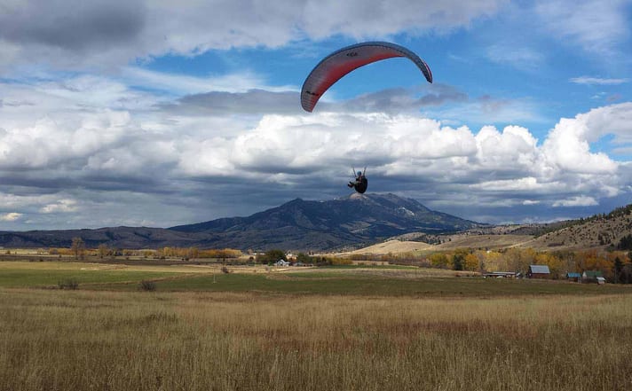
Pass Creek in Montana, USA, This site is occasionally used and is known for its hike-and-fly opportunities and potential for good cross-country (XC) flights. The main landing zone (LZ) is located 300 feet below the lower launch, across the road. There are various landing options, but all LZs are unimproved and covered with sagebrush, so it's advisable to walk the LZs before flight. To access the site, park on the west side of Rocky Mountain Road, about a mile past Morgan Road. Be mindful not to block the wire gate. An American flag in the nearby cemetery can serve as a wind indicator. Note that you must have a State of Montana recreation permit to hike and fly on state lands.The lower launch is a flat area on the hillside with room to set up and kite before launching. The Midway Launch, located above and north of the lower launch, (rarely used) is suitable for west to southwest winds and shares the same landing zones as the Training Hill Launch. For more advanced pilots (P3 recommended), the Upper Launch can be reached by hiking southeast from the Midway Launch. The primary launch direction here is south, but it can also be launched west to fly over the Training Hill Launch and back to the parking area. The landing zones are surrounded by private land, please get a site briefing before flying here. The Hazards to be aware of include barbed wire fences around the LZ areas, uneven terrain with clumps of sagebrush, and potential target shooting in the area. Midday conditions can generate strong thermic activity, so consider wind speed and direction to avoid rotor. For more detailed information, you can visit the following links: - Fly Bozeman Club: [Fly Bozeman](https://www.flybozeman.org/) - Site Guide: [Pass Creek Site Guide]
Local weather links visit:
https://406paragliding.com/resources/ Popularity: 45 Views
Map & Detailed Forecast
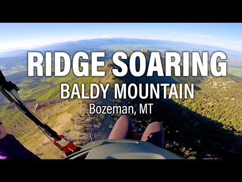
Baldy Mountain Bridgers , MT
best Conditions
NW
WNW
W
WSW
SW
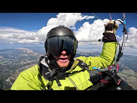
Located in Montana, USA, this paragliding site offers an elevation of approximately 2630 meters with a height difference of 1200 meters. It's a great spot for hike & fly enthusiasts due to the significant altitude change. Cross-country flights are possible here, although the site is not among the most popular. Please note, there are multiple locations named 'Mount Baldy' in the US, including several within Montana, so ensure you have the correct coordinates before planning your trip. The site record for distance is 32.3 km.
Click to watch video
Click to watch video
Popularity: 42 Views
Map & Detailed Forecast
Bridger, MT
best Conditions
W
WSW
SW
SSW
The launch site is been closed for many years
Popularity: 36 Views
Map & Detailed Forecast
Pomp Peak, MT
best Conditions
ESE
E
ENE
NE
Located in the scenic region of Montana, USA, this paragliding site offers an elevation of 2823 meters with a height difference of 1130 meters. It's a lesser-known spot, ideal for those who enjoy hike-and-fly adventures. The hike to the launch site is approximately 2 miles, and the area has been recently cleared of weeds and dead trees to improve accessibility.
The site is known for its scenic flights, providing breathtaking views of the surrounding landscape. However, it is not frequently used, making it a perfect choice for pilots seeking solitude and a more personal flying experience. The landing zone is on a road, so pilots should be prepared for a precise landing.
The site record for distance is 22.7 km, indicating the potential for some decent cross-country flying on the right day.
Popularity: 31 Views
Map & Detailed Forecast
Bridger Bowl Ski Resort
best Conditions
ESE
E
ENE
The Bridger Range in the USA offers a paragliding site with an elevation between 2300-2450 meters and a height difference of approximately 500 meters. This site is rarely used but provides opportunities for thermal ridge soaring and cross-country (XC) flights. The site record for distance is 38.1 km.
Popularity: 31 Views
Map & Detailed Forecast
North Cottonwood
best Conditions
NW
WNW
W
WSW
Located in Montana, USA, this paragliding site features a takeoff height of 2000 meters and a height difference of 405 meters. It's an occasionally used spot, primarily for soaring flights. The site record is 22.7 km.
To reach the launch area, you'll need to undertake a 2-mile hike. The path has been somewhat maintained, with weeds pulled and dead trees cleared. However, be prepared for a rustic experience. Landing is done on the road, so ensure you have the skills to manage this type of landing safely.
For more information on paragliding in Montana, you might want to check local paragliding clubs or forums.
Popularity: 30 Views
Map & Detailed Forecast
Johnson Canyon Johnson Creek, MT
best Conditions
WSW
SW
SSW
Located in Bozeman, Montana, USA, this paragliding site sits at an elevation of 2062 meters with a height difference of 340 meters. It is occasionally used for hike and fly activities and offers opportunities for thermalling. While it may not be the most popular site, it does provide good potential for cross-country (XC) flights. The site record for distance is 158.9 km.
Popularity: 29 Views
Map & Detailed Forecast