Ager, located in the Spanish Pyrenees, is a renowned site for paragliding, offering a variety of flying experiences for pilots of different skill levels. Here's a comprehensive overview based on the information gathered:
Ager is known for its great flying weather, which is generally best from February to the end of October. Pilots have reported making long duration and distance flights shortly after gaining their Club Pilot (CP) qualifications, indicating that Ager is conducive to learning and progression in paragliding. The conditions in September are described as calmer than mid-summer, making it an ideal time for beginners and those new to the site.
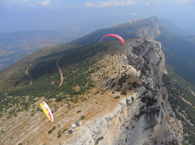
The main take-off area in Ager is large and unobstructed, with large open areas for landing, making it ideal for beginners in that respect. Evening flights are usually very smooth, with nice landing areas near amenities like bars. However, pilots should be cautious as conditions can be strong and turbulent at the wrong times of the day or year. With E/SE winds, certain areas can be extremely turbulent, especially in the beginning of the day.
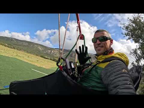
While Ager is suitable for beginners, it's recommended to fly with guidance, especially for pilots with low airtime. There are schools and guided trip options available, such as Passion Paragliding/XTC, which come highly recommended by those who have flown in Ager. These schools can provide the necessary safety oversight and ensure that beginners only fly in conditions they can handle, likely during early morning and evening flights.
For those looking to stay in Ager, there are options such as camping with kitchen facilities at affordable rates. Pilots have also mentioned the convenience of staying in bungalows at the campsite, which is close to the main launch site. It's advisable to stock up on groceries on the way from the airport for breakfast and pack lunches if staying in bungalows. The area has limited dining options, so planning for meals is essential[7]``[8].
Ager has a good community of pilots, including many who are involved in cross-country (XC) flying. The area is also known for hosting events like the Paragliding World Cup (PWC), which attracts pilots from around the world. This creates a vibrant atmosphere for flying and learning from experienced pilots.
Pilots looking to fly in Ager should be aware of the seasonal variations in flying conditions. While the summer months offer longer flying days, the conditions can be stronger and more challenging. Spring and autumn provide milder conditions that may be more suitable for pilots with less experience or those looking for smoother flights.
In summary, Ager offers a rich flying experience with its beautiful landscapes, variety of flying conditions, and supportive flying community. Whether you're a beginner looking to learn and progress or an experienced pilot seeking challenging conditions and XC opportunities, Ager has something to offer.
Closest partner

Alpyr
Where Paragliding | Ager | Spots map
The best spots of Paragliding | Ager
El Gravet
best Conditions
WSW
SW
SSW
S
SSE
SE
At an altitude of 1333 meters, this paragliding site is not frequently used but offers potential for good cross-country (XC) flights. The location provides a unique opportunity for those looking to explore less crowded skies and enjoy a more solitary flying experience. While it may not be the most popular site, its potential for XC flights makes it worth considering for adventurous pilots seeking new challenges.
Popularity: 78 Views
Map & Detailed Forecast
Ager Montsec d'Ares
best Conditions
WSW
SW
SSW
S
SSE
Ager, Spain, is a premier destination for cross-country paragliding and hang gliding, offering almost guaranteed sunshine and reliable flying conditions. Nestled against the backdrop of the Pyrenees, Ager provides a stunning mix of lakes, gorges, flatlands, and rocky terrain, making it an ideal spot for both beginners and experienced pilots.
The region boasts four main takeoff points:
1. **Raudoral**: This newly created takeoff allows for launches without needing to reach the top of Montsec. It faces south and is the first to catch the breeze as the slope heats up. Be cautious of east winds. The height to the Camping landing field is 500 meters. GPS: 31T 312693, 4656422.
2. **Gabrielo**: A spacious takeoff area suitable for both hang gliders and paragliders. It faces south and is not recommended with west winds. It is a good option when there is a north wind at the top of Montsec. The height to Ager is 550 meters. GPS: 31T 315102, 4655761.
3. **Coll d'Ares**: The main top takeoff, large and clear, with streamers to indicate wind direction. It faces south but can accommodate west winds. East winds can create rotor conditions, so in such cases, it's better to use the Sant Alis takeoff. The height to Ager is 960 meters. GPS: 31T 313555, 4657599.
4. **Sant Alis**: Located at a geodesic vertex, this takeoff offers incredible views of the Montseny, Moncayo, Guara mountain range, Pyrenees, Montserrat, Monte Caro, Prades, and Montsant mountain range. It faces southeast and is not suitable with west winds. The height to Ager is 1050 meters. GPS: 31T 315237, 4656809.
Landing options include:
- **Vertet Landing Field**: Near Camping Vall d'Ager, this rectangular field is oriented west-east. Be cautious of tree turbulence with north winds. GPS: 31T 315079, 4652814.
- **Cal Maciarol Landing Field**: One of the largest in the valley, suitable for all wind directions. It offers various services including a bar, accommodation, paragliding school, and shop. Be mindful of the power line on the main road.
- **Alternative Landing Field (300's field)**: Situated in front of the Coll d'Ares takeoff, used when there isn't enough height to reach the valley.
Ager is perfect for pilots of all levels, from beginners to those looking to fly cross-country. The area has hosted numerous competitions, including the Hang Gliding World Championship and the Paragliding British Open.
For more information, visit:
- [Entrenuvols School](http://www.entrenuvols.com)
- [Ager Parapent Club](http://www.agerparapentclub.com/)
- [Albatros School](http://www.albatros.es)
- [Local pilot Winston](http://www.wegofly.co.uk)
Tourist attractions in the area include the Colegiata de Sant Pere, Congost de Montrebei, and Restaurant Casa Mercè. For more details, check [Montsec Tourism](http://www.montsec.info/index.php?&idioma=en).
Weather updates can be found at [Meteo.cat](http://www.meteo.cat).
Popularity: 77 Views
Map & Detailed Forecast
Sant Alís
best Conditions
WSW
SW
SSW
S
SSE
SE
Sant Alis is a geodesic vertex offering breathtaking views of the Montseny, Moncayo, Guara mountain range, Pyrenees from Navarra to Girona, Montserrat, Monte Caro, Prades, and Montsant mountain range. The take-off point is located just to the left and in front of the firewatch cabin, facing South-East. It is important to avoid using this site with West winds. The elevation difference to Ager is 1050 meters. This site is regularly used for training, soaring, and cross-country flights. The height difference to the landing field, known as "camp de la T,"
Click to watch video
Popularity: 73 Views
Map & Detailed Forecast
Ager Raudoral La Nova
best Conditions
WSW
SW
SSW
S
SSE
SE
This paragliding site, situated at an altitude of 1228 meters with a height difference of 469-550 meters, is occasionally used and offers a low launch. Despite its infrequent use, it provides good cross-country flying opportunities. For more detailed information, you can refer to Coll d'Ares.
The takeoff area is located on the Montsec mountain range in Spain. It features a clean, fairly steep launch site that accommodates one paraglider at a time, while another prepares. The takeoff faces south and is the first to catch the breeze as the slope heats up. However, it is crucial to avoid this site when there is an east wind, as it becomes leeward and unsafe to use.
The height difference to the camping landing field is 500 meters. The GPS coordinates for the site are 31T 312693, 4656422.
For more information, you can visit: [Wikiloc - Paragliding Site](http://es.wikiloc.com/wikiloc/view.do?id=185078).
Popularity: 70 Views
Map & Detailed Forecast
Ager Tablones
best Conditions
SSW
S
SSE
Altitude: 1313 meters, Height Difference: approximately 670 meters. This site is considered easy to fly.
This location is regularly used and offers some potential for cross-country (XC) flights. It serves as an alternative launch site and is mainly used by the Albatros school/club.
Flights in this region are common. The site is located in Spain. The site record is 59.1 km.
The orientation is south. It is important to avoid using this site with west winds. This launch is particularly useful when the northern meteorological wind prevents takeoff from the summit. The elevation difference to the camping area is 550 meters, and to the Camp de la T, it is 500 meters.
For more information, you can visit [Paragliding Spain](https://www.paragliding-spain.com).
Popularity: 66 Views
Map & Detailed Forecast
Ermita Martirs
best Conditions
N
NE
NNE
This site has an elevation of 809 meters with a height difference of approximately 210 meters. It has limited activity with only one flight logged and some soaring opportunities.
Popularity: 65 Views
Map & Detailed Forecast
Montsec d'Ares
best Conditions
WSW
SW
SSW
S
SSE
La Noguera in Spain offers a paragliding site at an elevation of 1237 meters. This location is rarely used but is known for its hike-and-fly opportunities. For those interested in cross-country (XC) flying, good XC possibilities exist here. The site record for distance is 35.5 km.
Popularity: 64 Views
Map & Detailed Forecast
Coll de Comiols
best Conditions
NW
WNW
W
WSW
SW
At an elevation of 1220 meters, this site is occasionally used for paragliding. It offers opportunities for soaring and small cross-country flights. While it may not be the most popular destination, it can provide a unique experience for those looking to explore less frequented areas.
Popularity: 64 Views
Map & Detailed Forecast
Ager Francesas
best Conditions
SSE
SE
ESE
E
ENE
Altitude: 1323 meters, Height Difference: 670 meters. This site is considered medium-difficult. It is regularly used and offers some cross-country (XC) flying possibilities. There is an alternative launch available.
Flights in this region are common, and the site is located in Spain. The site record for distance is 59.1 km.
The orientation is East, with a gentle slope.
Popularity: 63 Views
Map & Detailed Forecast
Canal de la Xurulla
best Conditions
WSW
SW
SSW
S
SSE
At an elevation of 1545 meters, this paragliding site is not frequently used. However, it does offer the potential for cross-country (XC) flights. The site may not be the most popular choice among paragliders, but it can still provide a unique flying experience for those looking to explore less crowded areas.
Popularity: 63 Views
Map & Detailed Forecast
Castillonroy
best Conditions
WSW
SW
SSW
Located in the picturesque region of Castillonroy, Spain, this paragliding site offers an exciting experience for enthusiasts. The take-off point is situated at an altitude of 655 meters, with a height difference of 200 meters, making it a frequently used spot for thermal soaring and cross-country (XC) flights. The site has seen flights extending up to 61.6 km, showcasing its potential for long-distance paragliding.
To get there, Castillonroy is accessible via the N-230 road, positioned at the edge of the Catalonia and Aragon regions. The take-off area is reachable by car from the road connecting Baldellou and Castillonroy. The landing zone is conveniently located just below the take-off point, although the area is also suitable for longer flights towards the East or Northeast.
The village of Castillonroy offers various amenities, including places to eat, drink, and bathe, as well as a hostel for overnight stays. This location is also home to the renowned Ktxadorada community.
For more detailed information, you can visit the following pages:
- [Castillonroy Official Page](http://www.castillonroy.com/)
- [Ktx2 Paragliding Community](http://www.ktx2.net/?p=16)
- [Zonas de Vuelo](http://www.zonasdevuelo.com/zonasvuelo.html?fz=113)
The take-off area is at an altitude of 650 meters, facing South to Southwest, and is easily accessible. From the N-230 road between Lerida and Viella, take the turn-off for Castillonroy after passing Alfarrás. Cross the village towards Baldellou for about 4 km, then take the turn marked "quarry," make a 180° turn, and follow the well-maintained path for 3 km to reach the take-off point, which is just 100 meters away along a small path to the right. The maximum elevation difference is 250 meters, and you can land wherever you prefer.
Parking coordinates:
- Takeoff parking: 41.8951 N, 0.5331 E
- Landing parking: 41.8894 N, 0.5286 E
Popularity: 63 Views
Map & Detailed Forecast
Montsec d'Ares 2
best Conditions
WSW
SW
SSW
La Noguera - Ager in Spain offers a paragliding site that is not frequently used but has potential for good cross-country (XC) flights. The site record stands at 35.2 km. This location is suitable for hike and fly adventures or can be accessed using a 4x4 vehicle.
Popularity: 62 Views
Map & Detailed Forecast
Sapeira
best Conditions
NW
WNW
W
WSW
SW
This paragliding site is situated at an elevation of 1230 meters. It is infrequently used, primarily offering soaring flights. Due to its limited popularity, you might find fewer pilots here, which could be ideal if you prefer a quieter flying experience.
Popularity: 61 Views
Map & Detailed Forecast
Monsec Rubies
best Conditions
N
NNW
NW
WNW
NE
NNE
This site is situated at an elevation of 1620 meters. It is occasionally used for paragliding, and cross-country (XC) flights are possible from this location. The site may not be very popular, but it offers opportunities for those looking to explore less frequented areas.
Popularity: 60 Views
Map & Detailed Forecast
Castell de Mur
best Conditions
N
ENE
NE
NNE
At an elevation of 731 meters, this paragliding site is not frequently used. However, it does offer the possibility for cross-country (XC) flights. The site may not be the most popular, but it can still provide a unique flying experience for those looking to explore less crowded areas.
Popularity: 59 Views
Map & Detailed Forecast
Sant Llorenç de Montgai
best Conditions
SSE
SE
ESE
This paragliding site in Spain has an elevation of 439 meters. It is regularly used and offers good conditions for soaring. Cross-country (XC) flights are possible here, with the site record being 11.3 km.
Popularity: 59 Views
Map & Detailed Forecast
Balaguer
best Conditions
WNW
W
WSW
SW
SSW
This site, with an elevation of 307 meters, is occasionally used for paragliding. It offers opportunities for soaring flights, although it is not among the most popular destinations. The conditions here can be suitable for pilots looking for a less crowded experience.
Popularity: 58 Views
Map & Detailed Forecast
Vilanova de Meyá Cogulló
best Conditions
NW
WNW
W
S
SSE
SE
Located in Spain, this paragliding site offers a takeoff altitude of 981 meters with a height difference of approximately 390 meters. The site is considered medium-easy and is occasionally used, making it a fairly good option for cross-country (XC) flights. The best conditions for long ridge soaring are typically found with a light south wind, particularly in the direction of Ager.
The site features two launch directions, with the maximum takeoff altitude reaching 1000 meters. The orientations are Southeast and West, both of which are considered easy for launching.
Access to the site is via Lerida, taking the C1313 road to Artesa de Segre. From there, follow the local road to Vilanova de Meie. After crossing the village, continue for 4 km until you reach a sharp curve where you will find a sign for the Font Blanca track on the right. Follow this track, and another right turn will lead you to the antennas of Cogullo.
For more detailed information, you can visit [Zonas de Vuelo](http://www.zonasdevuelo.com/zonasvuelo.html?fz=333) or check out flight tracks on [Paragliding Forum](http://www.paraglidingforum.com/leonardo/tracks/world/alltimes/brand:all,cat:0,class:all,xctype:all,club:all,pilot:all,takeoff:15541).
Popularity: 57 Views
Map & Detailed Forecast
Ager Montsec d'Ares alternative
best Conditions
WSW
SW
SSW
S
SSE
Ager, located in Spain, is a prime destination for cross-country paragliding, offering reliable flying conditions and stunning views of the Pyrenees. The area features a mix of lakes, gorges, flatlands, and rocky terrain, making it an ideal spot for both hang gliding (HG) and paragliding (PG).
**Takeoff Points:**
1. **Raudoral:**
- Recently established, this takeoff allows for launches without needing to reach the top of Montsec. It is a clean, fairly steep takeoff suitable for a single paraglider at a time. It faces south and is the first to catch the breeze as the slope heats up. Avoid using it with east winds.
- Height to Camping landing field: 500 m.
- GPS: 31T 312693, 4656422
2. **Gabrielo:**
- This takeoff has a spacious area for setting up hang gliders and paragliders. It is a technical takeoff, facing south, and unsuitable with west winds. It is a good option when there is a north wind at the top of Montsec.
- Height to Ager: 550 m.
- GPS: 31T 315102, 4655761
3. **Coll d'Ares (Main Top Takeoff):**
- A large, clear takeoff area with streamers to indicate wind direction. It faces south but can accommodate west winds. Avoid using it with east winds.
- Height to Ager: 960 m.
- GPS: 31T 313555, 4657599
4. **Sant Alis:**
- Located at a geodesic vertex, this takeoff offers incredible views of various mountain ranges and landmarks. It faces southeast and should not be used with west winds.
- Height to Ager: 1050 m.
- GPS: 31T 315237, 4656809
**Landing Fields:**
1. **Vertet Landing Field:**
- Near Camping Vall d'Ager, this rectangular field is oriented west-east. Be cautious of tree turbulence with north winds.
- GPS: 31T 315079, 4652814
2. **Cal Maciarol Landing Field:**
- One of the largest landing fields in the valley, suitable for all wind directions. It offers various services, including a bar, accommodation, a paragliding school, and a shop. Watch out for the power line on the main road.
- GPS: 42.016560, 0.744987
3. **Alternative Landing Field (300's Field):**
- Located in front of the Coll d'Ares takeoff, this field is used when there isn't enough height to reach the valley.
**Additional Information:**
- Ager is perfect for pilots of all levels, from beginners to those looking to fly cross-country.
- The area has hosted numerous competitions, including the Hang Gliding World Championship and the Paragliding British Open.
- Ager offers a variety of outdoor activities such as kayaking, rock climbing, mountain biking, quad biking, tandem flights, and light aircraft flights.
- The region features a new observatory open to the public on weekends: [Parc Astronòmic Montsec](http://www.parcastronomic.cat/).
**Weather Hazards:**
- Be cautious of east winds. For weather updates, visit [MeteoCat](http://www.meteo.cat).
**Contacts:**
- Club Esportiu Entrenuvols: [Entrenuvols School](http://www.entrenuvols.com)
- Ager Parapent Club: [Ager Parapent Club](http://www.agerparapentclub.com/)
- Albatros School: [Albatros School](http://www.albatros.es)
- Local pilot Winston: [We Go Fly](http://www.wegofly.co.uk)
**Parking:**
- Takeoff parking GPS: 42.0465 N, 0.7464 E
- Landing parking GPS: 42.0174 N, 0.744 E
**Tourism:**
- Colegiata de Sant Pere
- Congost de Montrebei
- Restaurant Casa Mercè
For more information, visit [Montsec Tourism](http://www.montsec.info/index.php?&idioma=en).
Popularity: 56 Views
Map & Detailed Forecast
Cabrera
best Conditions
WSW
SW
SSW
This site is situated at an elevation of 667 meters. It is not frequently used, with only one recorded flight log and limited potential for cross-country (XC) flights. The site may be suitable for a brief, local flight but is not recommended for those seeking extensive paragliding experiences.
Popularity: 53 Views
Map & Detailed Forecast